Do you know what you're actually buying?
Search any NSW property - see live constraint and opportunity flags drawn from 140+ NSW Government datasets.
- Legal permissions zoning + clearing rights, to your boundary
- What is this land vegetation + plant communities, per hectare
- How can you use it land capability, water, access
- What it is worth value assessment + land tax position
- Conservation asset BSA viability + indicative credit estimate
- Risks & constraints the full 140+ layer screen
- Data sources every layer cited, versioned and dated
The full 24-page report
plus time with our team
- Everything in the Property & Environmental Assessment
- BSA Viability + dam-siting + privacy + risk register
- Comparable sales + Valuer General land value + land tax
- guided walkthrough with our team
- We read your report before the call
- Q&A on your specific situation and decisions
- Things worth thinking about next
- Optional Property Exclusivity Quote add-on at checkout
New to these terms? See our plain-English glossary of NSW rural land terms.
Frequently asked questions
What is included in the Education Package?
The full MapCheck report, plus a one-on-one guided walkthrough with the MapCheck team explaining what each constraint means for your specific property.
Who is the Education Package for?
Buyers, landholders or professionals who want the report explained and their questions answered, not just the PDF.
How does the guided walkthrough work?
After your report is delivered, the MapCheck team walks you through it and answers your questions about the constraints and opportunities on the land.
Is it a valuation or legal advice?
No. It is an indicative assessment and explanation drawn from NSW Government data.
Is GST included?
Yes. A$2,499 is in Australian dollars and includes GST.
See exactly what's in your report
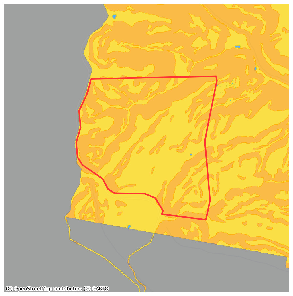
A 60-second walkthrough of a real MapCheck report on a 320-hectare Snowy Monaro property. Lot map, biodiversity layers, planning overlays, risk score - exactly what you'll receive on demand of ordering.
- Lot boundary overlaid on satellite imagery
- Every biodiversity & vegetation overlay flagged
- Proprietary dam-siting risk score
- PDF on demand
Choose the right report
for your situation
Side by Side feature comparison
| Land Constraint & Capability Assessment | Property & Environmental Assessment | Education Package | |
|---|---|---|---|
| Report Price |
Early Research: Tier 01
per/report
|
Comprehensive Report: Tier 02
per/report
|
Full Report + Guided Walkthrough: Tier 03
per/session
|
| Property Overview | |||
| Property Overview & Executive Summary ? Plain-English summary of what your property is, where it sits, and the headline constraints it faces. | ✓ | ✓ | ✓ |
| Satellite Imagery & Lot Mapping ? High-resolution satellite imagery with your lot boundary overlaid. | ✓ | ✓ | ✓ |
| Legal Permissions | |||
| Zoning & Permitted Uses ? LEP zoning, permitted/prohibited uses, development standards. | ✓ | ✓ | ✓ |
| NVR Clearing Categories ? Native Vegetation Regulation categories (Cat 1, 2, 2V) on your lot. | ✓ | ✓ | ✓ |
| Constraints Summary ? Consolidated list of constraints affecting development or use. | ✓ | ✓ | ✓ |
| What Is This Land? | |||
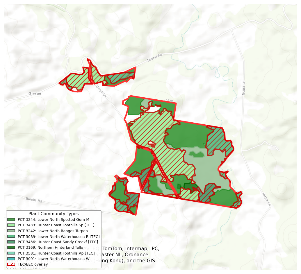
| Plant Community Type Mapping ? PCT mapping per NSW Government data: what's actually growing here. | ✓ | ✓ | ✓ |
| Geology, Soils & Landscape ? Geological substrate, soil types, landform mapping. | ✗ | ✓ | ✓ |
| Water & Stream Network ? Surface watercourses, riparian corridors, EPI riparian land. | BASIC | ✓ | ✓ |
| Groundwater & River Condition ? Groundwater bores nearby + river health condition index. | ✗ | ✓ | ✓ |
| How Can You Use It? | |||
| Land Capability & Carrying Capacity ? DSE-rated carrying capacity for grazing / agriculture. | ✗ | ✓ | ✓ |
| Dam Potential & Water Storage ? Modelled dam site potential and existing water storage. | ✗ | ✓ | ✓ |
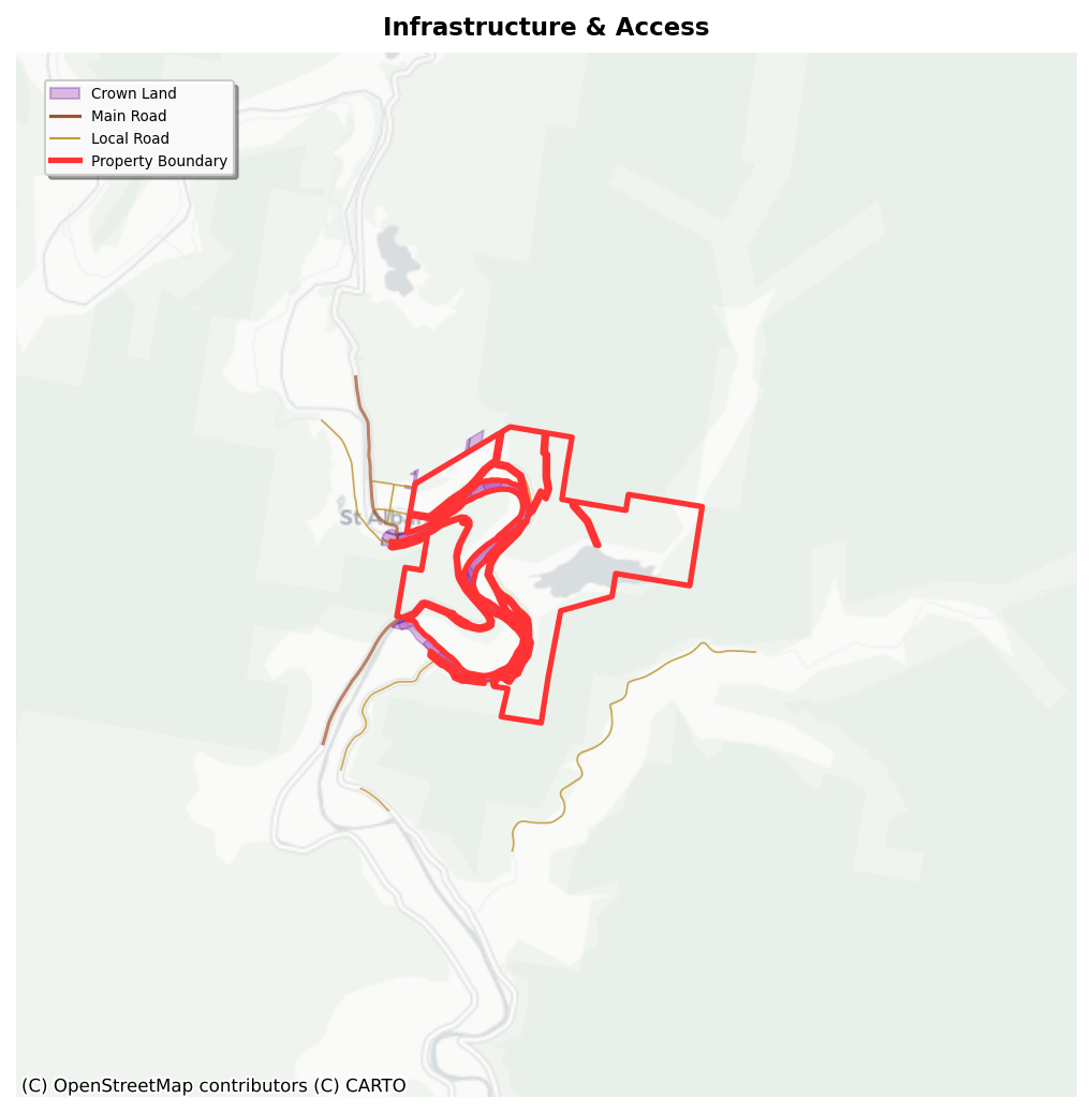
| Road, Power & Infrastructure Access ? Sealed road access, powerline proximity, utility corridors. | ✗ | ✓ | ✓ |
| Privacy Score ? MC:PRIVACY model. Visual privacy from neighbours and roads. | ✗ | ✓ | ✓ |
| What's It Worth? | |||
| Land Value & Comparable Sales ? Recent comparable sales and indicative valuation context. | ✗ | ✓ | ✓ |
| Conservation Asset Profile | |||
| BSA Viability Score & Credit Valuation ? Biodiversity Stewardship Agreement viability + indicative credit value. | ✗ | ✓ | ✓ |
| Koala Habitat Assessment ? Koala Management Area (KMA) and SEPP Koala Habitat layers. | BASIC | ✓ | ✓ |
| Native Title Search ? Native title claims and determinations affecting the lot. | ✓ | ✓ | ✓ |
| Bushfire & Risk Detail | |||
| Bushfire Prone Land & Fire History ? RFS bushfire-prone land categories + recorded fire history near the lot. | ✗ | ✓ | ✓ |
| Education Package Extras | |||
| guided walkthrough Call ? video walkthrough with our team. We read your report before the call and walk you through every flag and what it means for your situation. | ✗ | ✗ | ✓ |
| Q&A on Your Specific Situation ? Bring your questions; we'll work through them with reference to your report. | ✗ | ✗ | ✓ |
| Property Exclusivity Quote ? Optional add-on: pricing for exclusive use rights of the property data. | ✗ | ✗ | Optional Extra |
| Order BASIC: A$499 | Order ADVANCED: A$1,499 | Order EDUCATION: A$2,499 | |
When the data
needs explaining.
From property search to PDF delivery -
no account required.
Submit your property details
Address, Lot/DP, or both - use the search above or order form below.
Secure payment via Stripe
AU$2,499 incl. GST. PCI-DSS Level 1, 256-bit TLS. Full report + walkthrough booking link emailed.
24-page PDF delivered
on demand. Every report quality-checked by our team before it goes out.
Book your walkthrough
Calendar link emailed with your report. MapCheck team reviews your specific findings live with you.
Every layer mapped, every flag explained
Quick enough to run before you make an offer. Tells you what vegetation constraints apply and whether you need to look harder.
- Property overview and executive summary
- Satellite imagery and lot mapping
- Zoning and permitted uses
- NVR clearing categories (Cat 1, 2, 2v)
- Constraints summary (basic)
- Plant community type mapping
- Koala habitat potential (basic)
- Native title search
- Water and stream network (basic)
- Data sources and methodology
- Plain-English throughout
The full picture. Used by buyers, farmers and developers who want every answer before they commit.
- Everything in Land Constraint & Capability Assessment
- 12-factor constraints detail with mapping
- Bushfire mapping & RFS fire history
- Geology, soils and landscape classification
- Groundwater & river condition index
- Land capability and carrying capacity (DSE)
- Dam site analysis & potential
- Road, power & infrastructure access
- Privacy score
- Indicative land value & comparable sales
- Indicative financial scenarios (graze / BSA / sell)
- BSA viability score & indicative credit value
- Ecosystem credits by OTG
- Species credit candidates
- Developer offset liability estimate
- Full koala habitat assessment (KMA + SEPP)
You get the full Property & Environmental Assessment plus a guided walkthrough with our team. We'll walk you through what it means for your specific situation.
- Everything in Property & Environmental Assessment
- guided guided walkthrough call
- Plain-English walkthrough of findings
- Q&A on your specific situation
- Optional: Property exclusivity quote
Eight sections plus a guided walkthrough
with walk you through what we found.
Same 24-page Property & Environmental Assessment delivered with the Property & Environmental Assessment - every constraint, every regulatory flag, BSA Viability with ecosystem credit valuation, dam-siting, privacy, comparable sales, land tax estimates. Then a guided walkthrough with a MapCheck team member who's already read your report.
At a Glance
Traffic-light dashboard of every key metric - zoning, NVR clearing status, BSAL, vegetation, koala habitat, flood risk, bushfire, native title, crown land, agricultural capacity, dam potential, road access, grid power, privacy score, and land value. One page. 30 seconds.
What Can You Do With This Land?
Full LEP zone analysis with permitted and prohibited uses, NVR clearing categories mapped hectare by hectare (Category 1, 2, 2V, Sensitive), and a 12-factor constraints check covering flood, bushfire, BSAL, koala SEPP, contamination, heritage, native title, crown land, acid sulfate soils, and riparian corridors.
What's It Worth?
Valuer General land value with historical growth trend, estimated annual land tax, and comparable sales matched across four dimensions - vegetation type, zoning, geology, and cleared land. Includes financial scenarios comparing grazing as-is, BSA entry, and sale at market.
Is This Land a Conservation Asset?
Proprietary BSA viability score (0–100) with ecosystem credit valuation by Offset Trading Group, species credit candidates, developer offset liability calculation, active market demand from BCF charge data, Biodiversity Values Map designations, and the four-step pathway from BAM assessment to credit trading.
What Is This Land?
Plant Community Types with area, coverage, and EEC status. IBRA bioregion and Mitchell Landscape classification. Bedrock geology, dominant soils, and geological faults. Koala habitat assessment with KMA classification and suitability score. Threatened species records from BioNet with species credit potential.
How Can You Use It?
Land and Soil Capability class with DSE carrying capacity and cattle equivalents. Dam site eligibility using MapCheck's dam-siting model - eligible locations, estimated capacity in megalitres, and named watercourses. Road access (sealed and unsealed), power grid capacity, and privacy isolation score.
Risks & Constraints
Full detail pages for every flagged risk - bushfire category mapping with RFS data and NPWS fire history, crown land parcels with reserve types, koala SEPP obligations and habitat management requirements. Everything that could block, delay, or add cost to your plans.
Data Sources & Methodology
Every dataset listed with source agency, date, and validation status. MapCheck's spatial database contains 2.15 billion data points across 140+ lot-indexed tables covering 3.34 million NSW cadastral lots. Data accuracy validated to 97.2% across 15 independent checks.
Your Guided Walkthrough
A guided walkthrough with our team. They've read your full report before the call. You bring your situation, your decision deadline, your specific questions. Held over Zoom or Google Meet, scheduled at your convenience. Follow-up notes emailed afterwards.
Frequently Asked Questions
What you need to know about your property & environmental report.
-
What does the Land Constraint & Capability Assessment actually tell me?
It screens your property against 140+ biodiversity datasets - threatened species, ecological communities, biodiversity values mapping, koala habitat, riparian buffers and more. It tells you what's there, whether that's a development constraint or a stewardship opportunity. All data is sourced directly from NSW Government spatial databases.
-
Can I upgrade from a Land Constraint & Capability Assessment to a full Property & Environmental Assessment later?
Yes. After receiving your Land Constraint & Capability Assessment you can upgrade for the $1,000 difference - total AU$1,499. Your $499 is fully credited. You never pay twice for the same property.
-
What if my property has multiple lots?
One report covers all lots at the same address or within the same holding. List all your lot and DP numbers when ordering - there's no extra charge for multiple lots on the same property. If you don't know all your lot and DP numbers, that's OK, we'll find it for you using your address. It just speeds up the process if you know it.
-
How is this different from a standard conveyancing search?
Standard conveyancing searches (s10.7 planning certificates) cover zoning and some overlays. Biodiversity constraints sit in separate government spatial databases not automatically disclosed. MapCheck screens these specifically - which is why we find things standard due diligence misses.
-
Is this a formal ecological assessment?
No. A MapCheck report is a preliminary screening tool - it tells you what the government data says about your property. It is not a Biodiversity Assessment Method (BAM) report or a substitute for formal ecological survey. However, it's the right first step to determine whether a formal assessment is needed, and it can save you tens of thousands if the data shows one isn't required.
-
Can my solicitor or planner use it?
Yes. Our reports are used regularly by conveyancers, solicitors, town planners, and environmental consultants as preliminary screening tools. White-label versions are available for professionals who want to provide reports under their own branding.
-
Can I use this to identify land for a biodiversity stewardship site?
Yes. High BVMAP values, threatened ecological communities and riparian corridors are exactly what the BCT looks for in stewardship site candidates. If those values are present on your lot, your report will show it clearly - giving you the data you need to begin a conversation with the BCT or a stewardship site assessor.
-
How current is the data?
We pull from live government datasets at the time of report generation. NVR mapping, BioNet records, native title registers, and planning data are updated as source agencies publish changes. Each report includes the date of every dataset used.
Hunter Valley
Buyer avoided a $180,000 mistake
Hidden vegetation constraints on "cleared grazing land."
Inverell
$31.9M in stewardship value discovered
Farming family found conservation value dwarfing sale price.
Coffs Harbour
Saved $40,000 in unnecessary ecology fees
Council conditions overturned with MapCheck data.
Plain English
No jargon, no raw data dumps. Every finding explained clearly so you can act on it.
Quality checked
A member of our team reviews every report before it goes out. This is not an automated process.
140+ datasets
Biodiversity, geology, native title, sales history, electricity, water, heritage, contamination - all cross-referenced against your specific lots.
on demand delivery
Delivered as a PDF to your inbox. Most reports completed on demand.
Your property's biodiversity data
is ready right now.
Search free to see a preview - or order your full report and walkthrough now. PDF delivered on demand.