What environmental checks matter for NSW rural buyers
Before you sign anything, do you know what you're actually buying? NSW rural properties carry layers of regulation that standard searches don't...
4 min read
In June 2026 a Sydney builder, MAK Urban Group, withdrew its $4.8 million proposal for a data centre at 41 to 45 Barton Street in North Katoomba (council application X/419/2026). The plan was for six data rooms on a vacant industrial block. By the time it was pulled, a residents' group had gathered more than 730 petition signatures, a Greens councillor had called the noise assessment inadequate, and the mayor, Mark Greenhill, had labelled it "the wrong proposal in the wrong location".
Here is the part that catches people out: the land was zoned for it. The block is E4 General Industrial under the Blue Mountains Local Environmental Plan 2015, with a floor space ratio of 0.8 and a 12 metre height limit. On the zoning map, a data centre is a permissible use. So how does a permissible proposal end up withdrawn before it is even determined?
The answer is that the zoning map is one map. The site answers to about a dozen more, and on this parcel almost every one of them says something the zoning map does not.
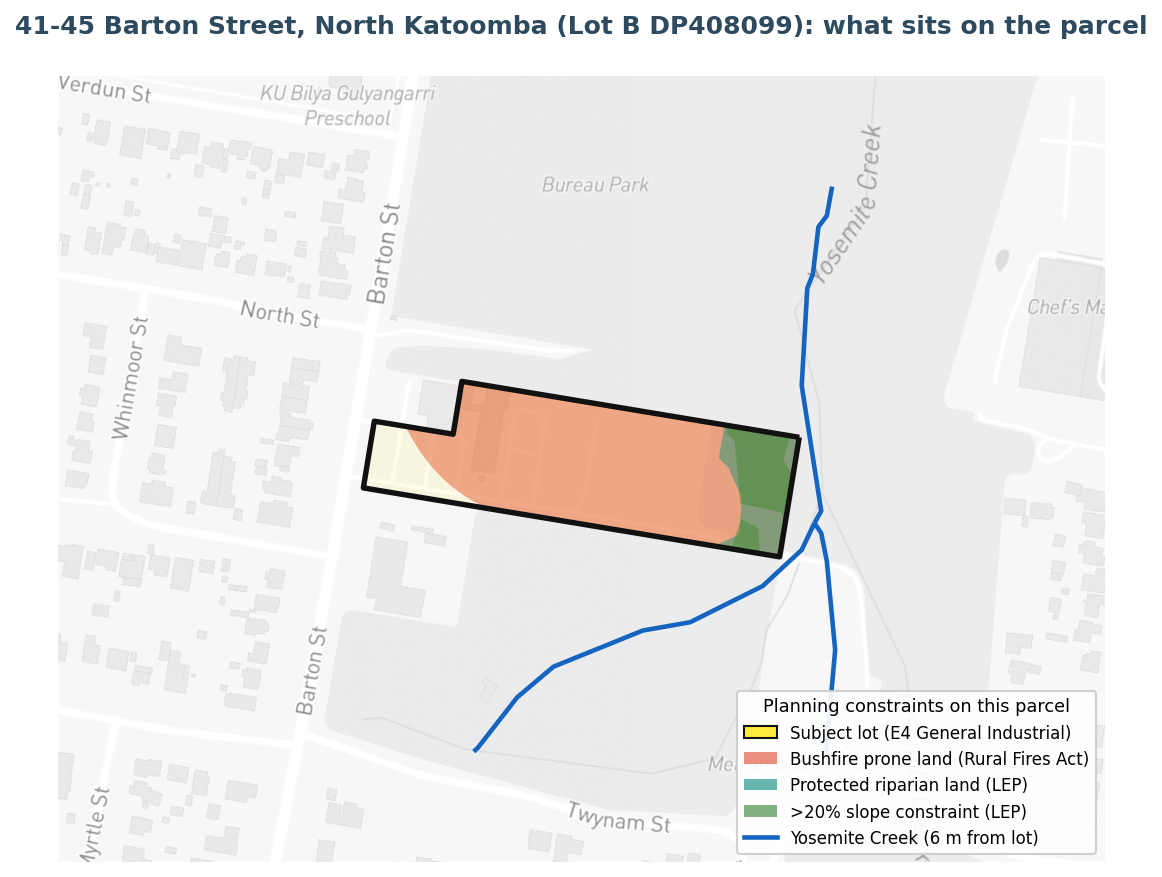
We ran the actual parcel, Lot B DP408099, through MapCheck. It is roughly 1.53 hectares. Eight separate constraint datasets land on it. The headline ones:
The constraint stack on the parcel, drawn from NSW planning and environmental datasets.
Then there is the setting. The block sits on the western edge of the E4 zone, and what it backs onto matters as much as the zone itself:
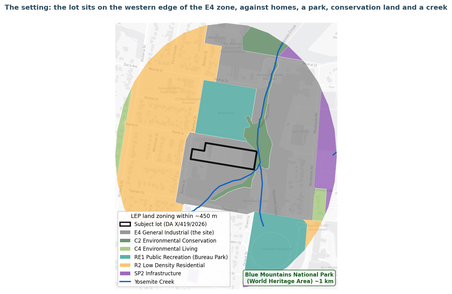
The zoning around the site: homes, a park and conservation land at the boundary.
None of that appears on the zoning map. All of it shapes whether a 24 hour, energy and noise intensive use can work here.
Checking a site of your own? Search any NSW property and see its constraint flags in seconds, free.
Check your property, freeTwo of those constraints do more than look bad on a map. They change the approval pathway and the politics.
Noise against a very quiet night. The residents' own figure for the night-time background level is 25 dBA, an extremely quiet acoustic environment. The applicant's acoustic report accepted that, in the council's words, "due to the low background noise levels during the night period there is a high risk of low frequency noise intrusion", and that the noise was "likely to be audible". Continuous chillers, cooling towers and ventilation do not pair well with a 25 dBA night and homes 30 metres away.
Hidden referral triggers. Development on bushfire prone land that is not a dwelling can require a Bush Fire Safety Authority from the Rural Fire Service. Works in or near a watercourse can require a Controlled Activity Approval from the Natural Resources Access Regulator. Each of those makes a proposal Integrated Development, with outside agencies in the decision. The council also flagged that the proposal might sit outside its own planning authority. Both of those referral triggers, bushfire and watercourse, are exactly the constraints that show up on the parcel.
It would be easy, and wrong, to read this as a developer who should have known better. MAK Urban Group did what most applicants reasonably do: it found vacant, appropriately zoned land and progressed it. The issue is not judgment, it is visibility. The eight constraints on this block are not on the zoning map, and assembling them by hand, across a dozen government portals, for every site a project might use, is a heavy piece of work that most people do after they have committed, not before.
That is the case for looking at many sites at once. With a bespoke search service across the constraint stack, a project team could screen multiple candidate properties in a single pass: bushfire buffer, protected riparian land and creek, slope, the residential and conservation land at the boundary, the World Heritage setting, and the referral triggers that follow from them. On that footing, the team may never have lodged here, or would have arrived with the right specialist assessments already scoped, because a better suited site would have surfaced in the same comparison.
MapCheck pre-computes roughly 55 constraint datasets against every one of the 3.3 million lots in New South Wales. For any parcel, the instrument stack comes back as one readable picture: what applies, what it means, and where the upside or the problem sits. For a project choosing between locations, the same engine compares a shortlist of sites side by side, so the question stops being "is this block zoned for it" and becomes "of the sites we could use, which one the land actually supports".
One block looked simple on the zoning map. The other ten maps told the real story. The only question is whether you see them before you lodge, or after a community does it for you.
Screening more than one site?
We compare a shortlist of properties across the full constraint stack in one pass, so the right site surfaces before you commit.
Site reports for developersTalk to our teamNew to the NSW terms above? See our plain-English glossary of NSW rural land terms - NVR, PCT, BSA credits, EEC, bushfire and riparian, all defined.
Before you sign anything, do you know what you're actually buying? NSW rural properties carry layers of regulation that standard searches don't...
Ask anyone who has taken an extractive industry proposal through the NSW planning system and they will tell you the same thing: the rock is usually...
Most vendors think of due diligence as the buyer's job, something that happens after an offer is on the table. A growing number are flipping that...
4 min read
Understanding the complex web of NSW biodiversity regulations can be challenging for property owners, whether you're planning residential development...
6 min read
Before you sign anything, do you know what you're actually buying? NSW rural properties carry layers of regulation that standard searches don't...

3 min read
Buying rural property in NSW means inheriting a regulatory environment that doesn't always introduce itself politely. The Biodiversity Conservation...